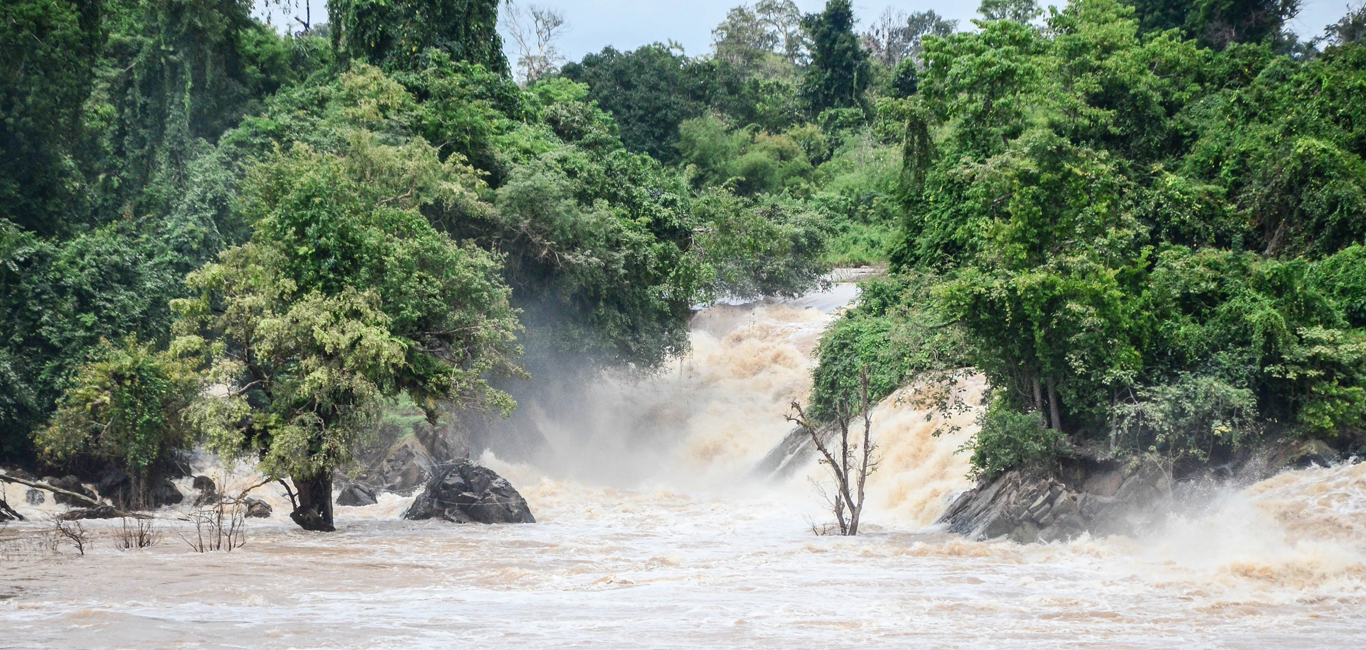
Jakarta welcomed the new year with a deluge of heavy rainfall between 31 December 2019 and 1 January 2020. With thousands of people displaced and over 60 fatalities recorded at the time of writing, the flooding serves to remind us of the perennial risk that flooding presents across Asia.
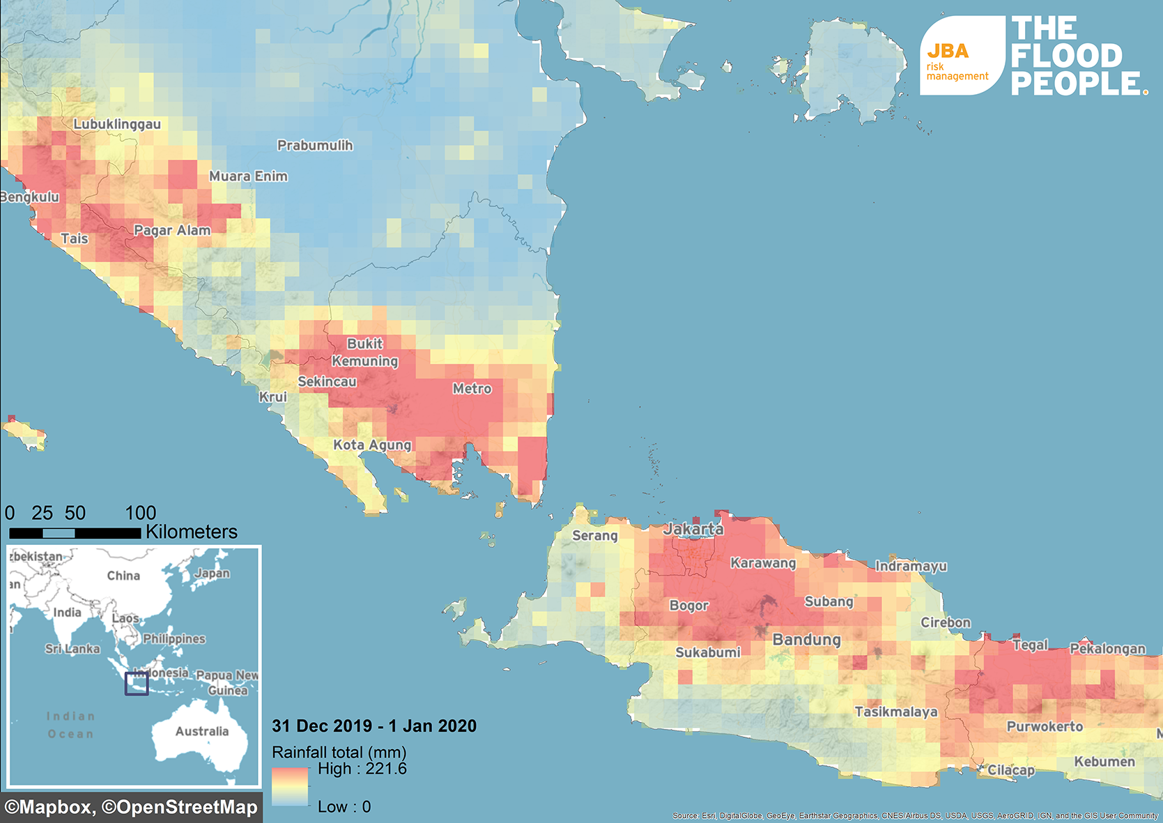
Figure 1: Observed Rainfall 31 December 2019 – 1 January 2020 (JBA Risk Management Limited™) (Data Source: NASA PMM, 2020)
The worst flooding in a decade
Indonesia’s Meteorology, Climatology and Geophysics Agency (BMKG) reported that the heavy rains were triggered by a convergence of wind patterns, with north-east winds meeting moist winds from the Indian Ocean to the south, leading to massive rain-producing clouds. Additionally, high temperatures increased the amount of water vapour in the air (ReliefWeb, 2020).
This north-east monsoon led to flooding across the Greater Jakarta area including in parts of West Java, Banten and Jakarta provinces. 103 districts and 308 sub-districts were affected by flooding as of 4 January 2020 with landslides reported in Banten and West Java provinces. High tides reportedly also confined water inland during the first week in January, worsening the flooding, with reports of 67 fatalities and up to 300,000 people displaced.
According to BMKG, the recorded rainfall intensity during 1 January 2020 at Halim PK Air Force Base in East Jakarta reached up to 377mm/day. There were also reports of floodwaters reaching the second floor of some buildings after rivers overflowed. The event is reported believed to have been the largest in terms of volume of water and scale since 2007 floods, when around 75% of Jakarta city was inundated, with 57 deaths and more than 400,000 people affected. Flood-related insurance claims from the 2007 event are estimated at USD $140 million (ReliefWeb, 2013).
As Figure 2 highlights, though more extreme localised rainfall was recorded in East Jakarta, data observed from NASA PMM over Greater Jakarta in a 24-hour period estimates precipitation ranged between 189-196mm. Comparing these estimates to the 41-year record (1979-2020) of rainfall in Central Jakarta (NOAA CDO, 2020) suggests a return period of around 50 years for the January floods.
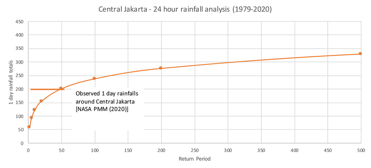
Figure 2: Return period analysis of the rainfall observed in Central Jakarta on 31 December 2019. NASA PMM (2020) daily total rainfalls are compared to observed data (NOAA Climate Data Online, 2020). A return period rainfall of approximately 50 years is estimated by JBA for this event. (JBA Risk Management Limited™).
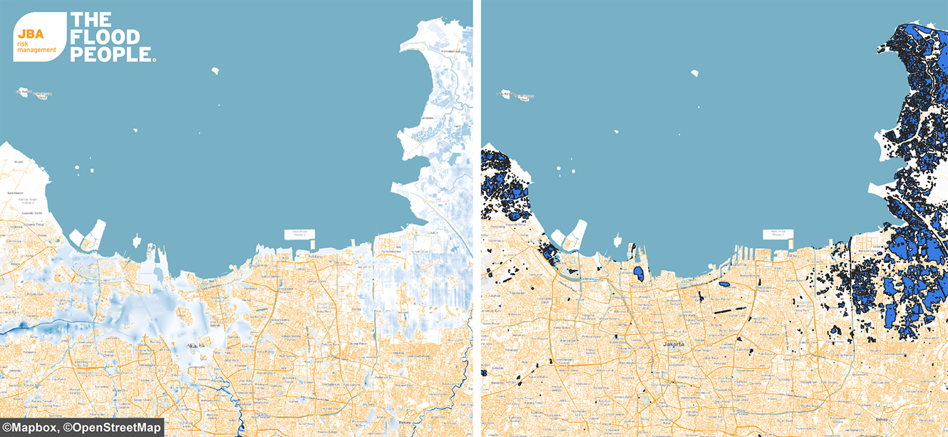
Figure 3: JBA’s 1-in-20-year Indonesia 30m river flood map showing Jakarta and the surrounding area (left) (JBA Risk Management Limited™) compared to satellite-detected surface water in Banten, Jakarta and Jawa Barat Province of Indonesia as observed from Sentinel-1 imagery acquired on 2 January 2020 (right) (Source: unitar.org). It is worth noting from the above comparison that the earth observation data does not appear to capture floodwater within urban areas. This flooding is captured within JBA’s flood map, which can be seen through the flood extent in Jakarta.
Jakarta’s increasing vulnerability to flooding
Jakarta is one of the most populous cities in the world and the largest in South-east Asia. The Greater Jakarta Area (Jabodetabek) has a population that exceeds 30 million people, while the city itself has a population of approximately 10 million. Jakarta’s geography makes the city particularly vulnerable to flood risk. Jakarta lies on a deltaic floodplain on the north-west coast of Java, at the mouth of the Ciliwung river on Jakarta Bay. Greater Jakarta is surrounded by several dormant volcanoes whose slopes form the upstream catchment areas of the 13 rivers that flow through Jakarta.
We have seen evidence of an increase in flooding frequency and severity in Jakarta in recent years, for a number of reasons.
The water catchment areas of the 13 rivers that flow through Jakarta, as well as the forests around the city, have been developed for residential and agricultural use over the years, meaning Jakarta is experiencing rapid urbanisation . The situation is intensified further due to the capacity of Jakarta’s rivers decreasing because of sedimentation, illegal settlements and poor waste management, which blocks waterways during heavy rainfall.
In addition to this worsening the effects of flooding, the coastal regions are highly susceptible to flooding due to land subsidence, which is exacerbated by rising sea levels. Only a quarter of Jakarta’s residents have access to piped water, meaning most residents and businesses rely on wells to obtain fresh water supplies (Business Insider, 2019). This draining of aquifers is contributing to the sinking of the city (Thomson Reuters Foundation, 2020).The northern Jakarta region is estimated to be sinking at approximately 150-250mm every year, with 40% of the city now believed to be below sea level (World Bank, 2016; Wall Street Journal, 2020). The latest estimates suggest that 95% of North Jakarta could be entirely submerged by 2050 (BBC, 2018).
Continued rapid urbanisation could further alter the river catchment response and lead to increasing groundwater extraction. This is likely to exacerbate flood risk even further with more property and people exposed and infrastructure struggling as Jakarta continues to race against sea level rise (Wall Street Journal, 2020).
Flood mitigation projects have taken place in recent years, designed to improve protection of the city from floods. For example, the government-led National Capital Integrated Coastal Development Scheme (NCICD) is designed to enhance flood protection for the northern part of the city through creation of a seawall. However, flood risk remains an ongoing major cause for concern. This was highlighted further in 2019 when it was reported that the President of Indonesia proposed to move the administration functions of the capital city to the island of Borneo to alleviate pressure on Jakarta.
In Indonesia, there is a large protection gap (the difference between losses for insured property assets and potentially insurable property assets) for flood. SwissRe estimated the 100-year flood protection gap in the metropolitan area of Jakarta would increase from USD $9 billion in 2013 to USD $25 billion in 2023 (Swiss Re, 2013).
For further information on historical events and Jakarta’s unique susceptibility please see a previous blog post from our Event Response team produced last year here.
JBA Risk Management has nationwide return period flood maps for Indonesia and a probabilistic flood model at 30m resolution. Please get in touch for further information.
References
https://reliefweb.int/report/indonesia/situation-update-no-1-massive-floods-greater-jakarta-area-indonesia-05-january-2020
https://reliefweb.int/report/indonesia/flash-update-no-02-flooding-jakarta-metropolitan-area-indonesia-03-january-2020
http://blogs.worldbank.org/eastasiapacific/urban-flood-resilience-indonesia-new-approaches-through-urban-design-lens
http://documents.worldbank.org/curated/en/153081567169469254/pdf/Indonesia-Jakarta-Urgent-Flood-Mitigation-Project.pdf
https://www.wsj.com/articles/torrential-rain-flooding-and-landslides-claim-16-lives-in-jakarta-11577970970
https://www.nytimes.com/interactive/2017/12/21/world/asia/jakarta-sinking-climate.html?register=google
https://www.theguardian.com/world/2020/jan/06/jakarta-floods-indonesia-recovery-effort-begins-as-city-counts-cost-of-worst-deluge-in-a-decade
https://www.swissre.com/dam/jcr:1f3b0c6d-75ef-4faa-957f-e965507216f0/Factsheet_NatCat_Protection_Gap_Jakarta.pdf
https://www.aljazeera.com/news/2020/01/indonesia-floods-death-toll-hits-66-rain-expected-200106090620594.html
https://www.bbc.co.uk/news/world-asia-44636934.
https://www.businessinsider.com/indonesia-capital-move-jakarta-borneo-environmental-concerns-2019-8?r=US&IR=T
http://news.trust.org/item/20200107131405-e3g6q/