Powerful Hurricane Milton crashes into Florida with Unrelenting Force
Hurricane Milton has emerged as one of the most significant hurricanes in recent history. As it makes its way across Florida it is sure to leave behind widespread destruction and devastation. This report builds on JBA’s initial overview to delve into the unique factors that contributed to Hurricane Milton’s severity – including its rapid intensification, path of approach to Florida and the compounding impact on a state still recovering from Hurricane Helene.
Power and Pressure: Milton's Rapid Intensification and Record-Low Pressure
Hurricane Milton’s intensity – and the remarkable speed at which it transformed from a tropical storm to a major hurricane - is one of the most defining features. Tropical cyclones intensify through a process that involves extracting heat energy from warm ocean waters, which fuels the storm’s convection and strengthens its wind circulation.
The oceanic conditions for Milton were conducive to its intensification. The Gulf of Mexico, where Milton formed, is currently experiencing record-breaking sea surface temperatures of upwards of 30 °C (Washington Post, 2024). Add to this high relative humidity (which provides moisture to enhance the development of deep convective thunderstorms) and low vertical wind shear (which allows the storm to maintain a coherent vertical structure to transfer energy) and Milton was able to intensify by an extraordinary 90 mph in a 24-hour period (NBC, 2024a). This meant that Milton transitioned from a tropical storm to a Category 5 hurricane in just one day.
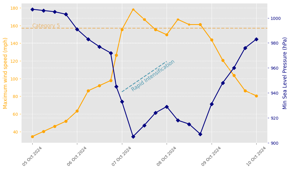
Figure 1: The formation of Hurricane Milton from October 5 to October 10, 2024, showing maximum wind speed and minimum sea level pressure. Two key events are highlighted: the rapid intensification phase and the point at which the storm reached Category 5 status.
Another feature of Hurricane Milton, closely related to its intensity, is its size. Initially, as Milton intensified it was a very small storm, with a compact pinhole eye. Due to the conservation of angular momentum, this small structure helped the storm maintain high windspeeds. However, as it progressed, bands of rain and thunderstorms developed on its outer edges. These bands coalesced to form a secondary eyewall, which gradually moved in and replaced the original, smaller eye (NBC, 2024a).
This phenomenon is called an eyewall replacement cycle (ERC) and has different implications for Milton as it moves across the Gulf of Mexico. The ERC caused the storm to expand its reach, as the radius of maximum winds shifted to the outer eyewall, transforming Milton from a tightly wound hurricane into a sprawling system. Immediately after the ERC, Milton’s strength weakened slightly before entering a period of re-intensification. This caused Milton to be downgraded to a Category 4 storm before later returning to a Category 5 storm on October 8.
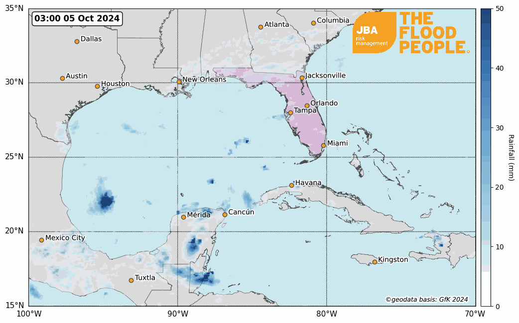
Figure 2: Satellite-observed rainfall for Gulf of Mexico between October 5 and October 10, 2024. Rainfall data source: NASA GPM 3-hour rainfall accumulation (2024), TC track: National Hurricane Center (2024a). Animation produced by JBA Risk Management (2024).
Cities in the Path: Milton’s Landfall and Impacts
A combination of Milton’s trajectory, wind field and location of landfall along Florida’s west coast significantly influenced where the highest impacts were observed.
The bathymetry, or depth of water, of Florida’s west coast amplifies storm surges. Here, water depths are relatively shallow (approximately 200 m depth, 500 km offshore) and gradually decreases towards the coast. As Milton approached the coast, the Gulf’s shallower depths result in less space for storm surge water, amplifying the surge height and driving it further inland leaving more communities at risk (Bulletin of the Atomic Scientists, 2024a).
Like all Northern Hemisphere hurricanes, Milton’s wind field rotated in an anticlockwise direction. As the storm made landfall, strong offshore winds north of the hurricane eye drove surge water away from the coastline, and strong on-shore winds south of the hurricane eye drove surge water towards the coastline. Coastal regions north of the eye, such as Clearwater Beach tidal gauge, observed a Mean Higher High Water (MHHW) of 0.4 m Wednesday morning, which is lower than regions south of the eye, such as Fort Myers tidal gauge which observed a MHHW of 1.6 m (NOAA, 2024b). Such regional differences in storm surge height would lead to large differences in the surge’s impact.
The Tampa metropolitan area, located adjacent to Tampa Bay, is home to 3 million residents (BBC, 2024a) and is an important port city, contributing $18 billion USD to the state’s economy (Port of Tampa Bay, 2024a). The city and its port are vulnerable to coastal flooding, especially when storm surge water funnels and gets trapped in the Bay.
Strong offshore winds minimized the storm surge height in the Tampa Bay region as Milton made a slight turn right making landfall just south of the city. This left the docks at Tampa’s port largely undamaged according to initial reports (Port of Tampa Bay, 2024b).
Ensemble forecasts 36 hours prior to landfall still showed some uncertainty in Milton’s trajectory, with possible landfall scenarios between Port Charlotte to the south and Spring Hill to the north of Tampa (ECMWF, 2024). Had the storm maintained its east-northeast trajectory and made landfall further north, surge water would have funneled and pooled in the Bay, inundating areas of critical infrastructure and property.
This is not to suggest that Tampa escaped significant impact: upon landfall Milton was a Category 3 storm (NHCa, 2024) – one capable of causing devastating damage. Wind speeds of 100 mph were recorded, leading to significant wind damage to properties, infrastructure and construction sites in the surrounding area (Guardian, 2024).
Late-Season Surge: Milton’s Arrival in a Critical Period
Milton made landfall just two weeks after Hurricane Helene brushed past the west coast of Florida. Debris caused by Helene was a common sight along roads in coastal neighborhoods as the clear-up operation continued. There was widespread concern that this debris was going to be airborne or float in Milton’s strong wind and storm surge, causing more damage to surrounding properties.
A Storm in Context: Milton and Helene
Hurricane Milton is undoubtedly an incredibly intense major hurricane, but how does it compare with past events?
At its peak intensity, whilst still in the Gulf of Mexico, Milton ranks as the fifth most intense hurricane on record (NHCa, 2024). Upon landfall, it had transitioned to a Category 3 storm; this compares to Helene, which was a Category 4 storm at landfall. Yet, the categorization alone does not tell the full story.
Tropical cyclones are characterized by their maximum sustained wind speeds, but they can cause damage through various means: winds, storm surge and precipitation. For example, the city of Tampa broke its record for total October rainfall in just a single day as Milton made landfall (The Weather Channel, 2024). The torrential rain associated with the storm is likely to cause flash flooding in many areas. In addition to the huge storm surge, these factors will contribute to increased strain on the state's river network.
Whilst the intensity of Milton is significant, the track also exhibits some unusual characteristics. Milton formed in the southwest Gulf of Mexico and managed to remain over the warm oceans, allowing it to strengthen rather than weaken. This is atypical for October hurricanes which typically originate in the Caribbean (NHC, 2024b). Once over land the storm travelled directly across central Florida – meaning it did not follow the path of Helene and directly cause significant impacts in North Carolina. However, the path takes the hurricane close to highly populated cities which will likely exacerbate its impacts.
The until now perpendicular path of Milton's approach to Florida is uncommon for hurricanes in this region. This direct trajectory can lead to different patterns of storm surge and wind impact compared to storms that approach at an angle. A perpendicular approach may expose a broader stretch of coastline to the storm's strongest forces, potentially increasing the overall impact on affected areas.
Reflections on the 2024 Hurricane Season
At the start of the 2024 hurricane season, most predictions suggested it would be a highly active one. The National Oceanic and Atmospheric Administration (NOAA) predicted an above-normal hurricane season due to several oceanic and atmospheric conditions. These included near-record ocean temperatures, the development of La Niña conditions, and reduced Atlantic trade winds (NOAA, 2024a). However, by mid-September—typically the peak of the hurricane season—only seven of the predicted 15 to 25 named storms had occurred.
This lull in hurricane activity has been linked to an unusual northward shift of the Intertropical Convergence Zone (ITCZ), a band of low pressure near the equator associated with high levels of precipitation. This shift caused the West African monsoon to extend further north, bringing unprecedented rainfall to the Sahara Desert. As a result, African easterly waves - from which tropical cyclones often spawn - also shifted northward, emerging over cooler Atlantic waters off the coasts of Mauritania and the western Sahara. These regions are less conducive to tropical cyclone genesis due to lower sea surface temperatures and drier air, effectively suppressing the development of storms (The Conversation, 2024).
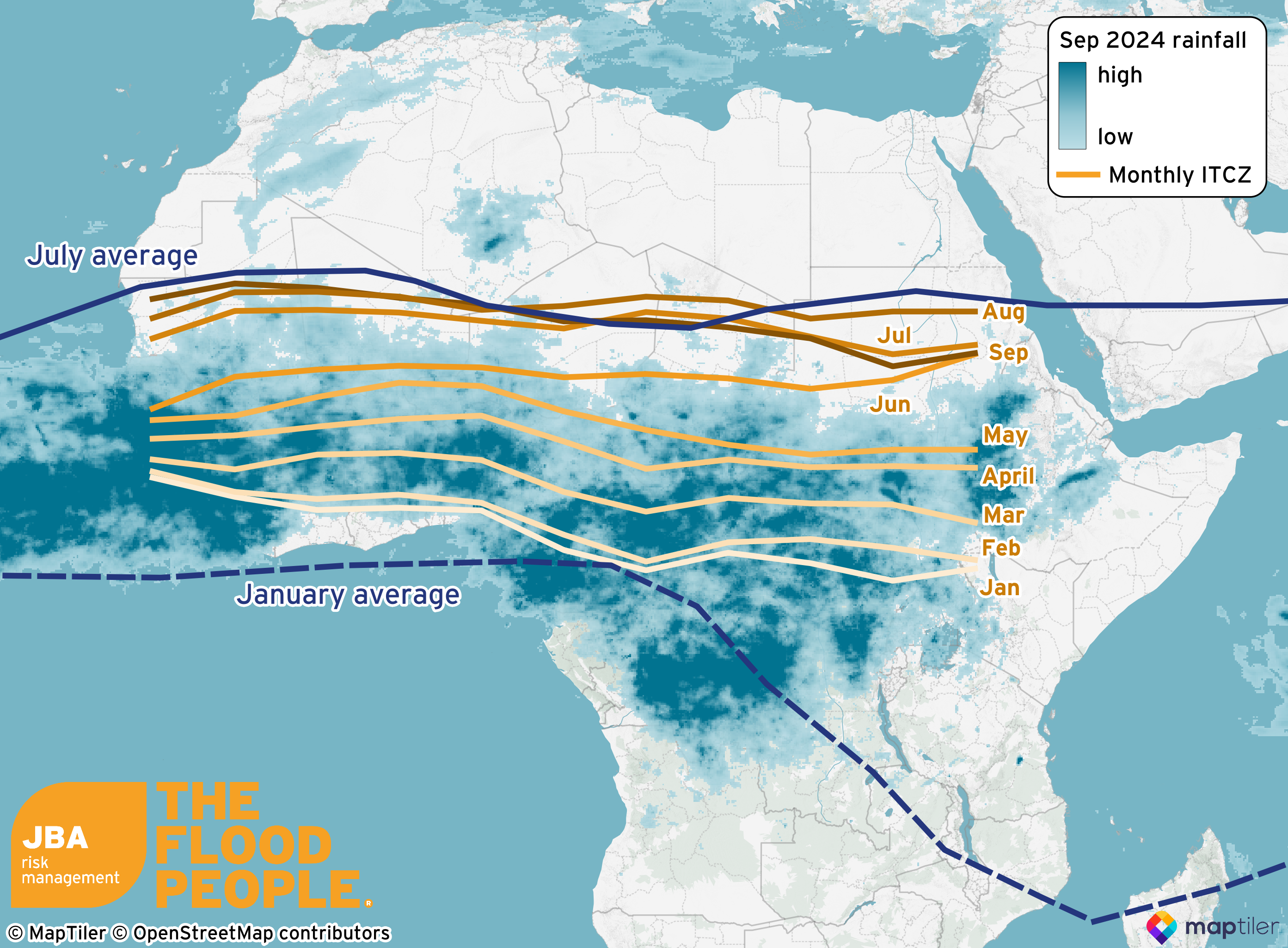
Figure 3: Location of the ITCZ over Africa from January 2024 to September 2024 (orange lines; NOAA Climate Prediction Center, 2024) with average January and July ITCZ positions (blue lines; Whiting Blome et al., 2012) and rainfall accumulation for September 2024 (NASA, 2024).
Additionally, increased Saharan dust and dry air inhibited convection over the tropical Atlantic, further reducing hurricane activity. The Madden-Julian Oscillation (MJO), which regulates convective activity in the tropics, has also been in an unfavorable phase for hurricane genesis. These factors combined to suppress hurricane activity during what was expected to be an active season (The Conversation, 2024).
The quiet season has dramatically changed in the past few weeks. The West African monsoon has retreated southward and the MJO has advanced eastward into phases that favor hurricane formation in the Atlantic basin (Colorado State University, 2024). As a result, Hurricane Milton, along with hurricanes Helene, Isaac, Kirk and Leslie, is one of several hurricanes to have developed over the past few weeks, meaning we are now experiencing a late peak in hurricane activity.
JBA provides a probabilistic catastrophe model for the United States, offering flood risk insight for both current-day and future scenarios.
A flood footprint for this event detailing extents and depths of the flooding in areas affected will be released in due course. Email eventresponse@jbarisk.com for more details.
References
BBC, 2024a. “Where is Hurricane Milton heading?” [Online]. Available at: https://www.bbc.co.uk/news/articles/c981q381p58o [Accessed 10 October 2024]
Colorado State University, 2024. COLORADO STATE UNIVERSITY FORECAST OF ATLANTIC HURRICANE ACTIVITY FROM OCTOBER 1–14, 2024 AND OUTLOOK FOR OCTOBERNOVEMBER CARIBBEAN ACCUMULATED CYCLONE ENERGY. [Online]. Available at: https://tropical.colostate.edu/Forecast/2024-1001.pdf [Accessed 10 October 2024]
ECMWF, 2024. Tropical cyclone activity (including genesis). European Centre for Medium-Range Weather Forecasts Charts. [Online]. Available at: https://charts.ecmwf.int/products/cyclone?base_time=202410090000&product=tc_plumes&unique_id=14L_MILTON_2024 [Accessed 10 October 2024]
Guardian, 2024. At least four killed as Florida begins to assess Hurricane Milton destruction. [Online]. Available at: https://www.theguardian.com/us-news/2024/oct/10/hurricane-milton-aftermath-damage [Accessed 10 October 2024]
NASA Global Precipitation Measurement (GPM), 2024. Precipitation Data Directory. [Online]. Available at: https://gpm.nasa.gov/data/directory [Accessed 10 October 2024]
NBC, 2024a. “The Science of How Hurricane Milton Became Such a Monster.” [Online]. Available at: https://www.nbcnews.com/science/science-news/hurricane-milton-science-intensity-structure-size-threat-rcna174609. [Accessed 10 October 2024]
NHC (National Hurricane Center), 2024a. Hurricane Milton Tropical Cyclone Update. [Online]. Available at: https://www.nhc.noaa.gov/archive/2024/al14/al142024.update.10100030.shtml [Accessed 10 October 2024]
NHC, 2024b. Tropical Cyclone Climatology. [Online]. Available at: https://www.nhc.noaa.gov/climo/#ori. [Accessed 10 October 2024]
NOAA 2024a, NOAA predicts above-normal 2024 Atlantic hurricane season. [Online]. Available at: https://www.noaa.gov/news-release/noaa-predicts-above-normal-2024-atlantic-hurricane-season [Accessed 10 October 2024]
NOAA, 2024b. Find Your Local Tides and Currents. [Online]. Available at: https://tidesandcurrents.noaa.gov/map/index.html [Accessed 10 October 2024]
Port of Tampa Bay, 2024a. Fitch Ratings improves Port Tampa Bay’s rating to A+ and maintains ratings outlook at Stable. [Online]. Available at: https://www.porttb.com/2023/11/fitch-ratings-improves-port-tampa-bay-s-rating-to-a-and-maintains-ratings-outlook-at-stable [Accessed 10 October 2024]
Port of Tampa Bay, 2024b. Port Recovery Alert - Hurricane Milton. Port of Tampa Bay. [Online]. Available at: https://www.porttb.com/posts?id=ED56E5DC-AB2F-4B42-BB4D-5A75952D4F71 [Accessed 10 October 2024]
The Weather Channel, 2024. Hurricane Milton Moving Away From Florida With High Winds, Flooding Rain, Storm Surge. [Online]. Available at: https://weather.com/storms/hurricane/news/2024-10-09-hurricane-milton-forecast-landfall-florida-storm-surge-wind [Accessed 10 October 2024]
Washington Post, 2024. “What is making Hurricane Milton so ferocious”. [Online]. Available at: https://www.washingtonpost.com/climate-environment/interactive/2024/hurricane-milton-helene-marine-heat-wave-storms/ [Accessed 10 October 2024]
Whiting Blome, M., Cohen, A.S., Tryon, C.A., Brooks, A.S. and Russell, J., 2012. The environmental context for the origins of modern human diversity: a synthesis of regional variability in African climate 150,000–30,000 years ago. Journal of human evolution, 62(5), pp.563-592.