Speak to our team
Interested in learning more about how our flood data can help you? Fill in the form below to speak to one of our team.
The current 2020/2021 La Niña phenomenon, which results in wetter-than-normal conditions for the South-east Asian region, developed in October 2020 and brought heavy rainfall to Indonesia and much of the wider region since the beginning of January (World Meteorological Organisation, 2020). As a result, rivers have overflowed to flood neighbouring villages and farmland.

Figure 1: Daily rainfall (24-hour accumulation period) distribution map from 10 to 15 January 2021 across Indonesia. (Data source: Precipitation Measurement Mission, NASA, 2021)
Meteorological conditions
The 2020/2021 La Niña peaked between December 2020 and January 2021 and has resulted in high-intensity and prolonged rainfall across the South-east Asian region including Indonesia, Malaysia and Singapore. The event was categorised as ‘moderate to strong’, with the last event of this strength occurring in late 2010 to early 2011 (World Meteorological Organisation, 2020). Singapore received one of the highest daily rainfalls in 39 years (The Straits Times, 2021b). In Johor, on the south of the Malaysia peninsula, flood events were widely reported and at least 48,000 people had to be evacuated from their houses (The Straits Times, 2021c).
La Niña exacerbated conditions already in place as a result of the North-east monsoon, experienced across South-east Asia from December to February each year. The monsoon brings high amounts of rainfall annually which, coinciding with La Niña, has resulted in widespread flooding in Indonesia.
Indonesia floods
An estimated 75 flood events occurred across Indonesia between 1-5 January and 10-15 January in the provinces of Aceh, East Java, West Java, Central Java, North Kalimantan, and South Kalimantan (Figure 2).
 Figure 2: Provinces affected by the floods between 1 and 14 January 2021 in Indonesia (Data sources: Relief Web, 2021a; ReliefWeb, 2021c).
By 14 January, the International Federation of Red Cross and Red Crescent Societies (IFRC) estimated that a total of 149,550 people had been affected by the floods (Relief Web, 2021a). Floods were especially severe in Bandung Regency in West Java, Tabalong in South Kalimantan and Solok City in West Sumatra, where floodwaters were approximately 1-1.5m deep (FloodList, 2021a; FloodList 2021b; FloodList 2021c).
Bandung Regency, West Java
On 10 January, high intensity rainfall caused the Citarum River to overflow, with floods affecting the Soreang, Dayeuhkolot, Baleendah and Bojongsoang districts in Bandung. The Regional Disaster Management Agency (BPBD) of Bandung Regency reported that over 66,400 people were affected by the flood on the same day. Floodwaters reached depths of up to 1m and have submerged and damaged 10,572 houses, 28 schools, and 46 places of worship (ReliefWeb, 2021b).
South Kalimantan
South Kalimantan witnessed prolonged rainfall on 12 January which caused flooding in an estimated 25 villages across seven sub-districts in Banjar Regency and Tabalong Regency after the Uwi and Tabalong rivers overflowed (FloodList, 2021c). Flooding worsened over the following days with rainfall peaking on 14 January – the provincial capital, Banjarmasin City, recorded a rainfall total of 270mm within 24 hours (FloodList, 2021d). The floods resulted in at least 15 deaths by 14 January and led the provincial government to declare a state of emergency (The Straits Times, 2021a). Reports and images from the affected areas showed floodwaters with depths up to 1m (FloodList, 2021c).
The situation worsened again significantly on 14 January due to high tidal conditions and resulted in floods in nine sub-districts including Tapin District, Banjarbaru City, Hulu Sungai Tengah District and Hulu Tengah Selatan District. Water depth reached up to 1.5m.
By 17 January, at least 210,140 people had been affected by floods in South Kalimantan alone, with 39,000 people displaced, and 24,379 houses were reported to be inundated in the region by 19 January (ReliefWeb, 2021c). The current flood situation in South Kalimantan was described by President Jokowi as ‘the biggest flood in maybe 50 years’ (The Straits Times, 2021a).
Rainfall Analysis
JBA performed an extreme value analysis using historical gridded rainfall at four locations across Indonesia to estimate return periods for the rainfall seen in January (Figure 3).
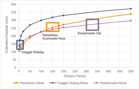
Figure 3: Return period analysis for four locations in Indonesia with the highest rainfall recorded on 14 January 2021. A Weibull distribution curve was fitted to the historical rainfall data for Tunggul Wulung (Central Java), Banjarbaru and Syamsudin Noor (South Kalimantan) while a General Pareto Distribution curve was fitted to the historical data for Banjarmasin City (South Kalimantan). (Historical Data source: Physical Sciences Laboratory NOAA, 2021; Daily recorded precipitation data: BKMG, 2021; Analysis and graphics: JBA Risk Management Limited)
From 13 to 14 January 2021, Banjarbaru and Syamsudin Noor climate stations, located in Banjarmasin, South Kalimantan, recorded the highest rainfall within 24 hours at 255mm and 249mm respectively (BMKG (Indonesian Agency for Meteorology, Climatology and Geophysics), 2021), with an estimated return period of 150 years. Tunggul Wulung, Central Java, received 138mm rainfall over the same 24-hour period (BMKG (Indonesian Agency for Meteorology, Climatology and Geophysics), 2021), with an estimated return period of 2 years. Banjarmasin City, South Kailimantan, recorded a rainfall total of 270mm on 14 January with an estimated return period of 325 years (FloodList, 2021d).
Flood and insurance in Indonesia
Indonesia is significantly at risk of flooding each year. Despite this, Indonesia has a lower non-life insurance penetration (expressed as a % of GDP) than other countries in South-east Asia, with a penetration rate of 0.6% compared to 1.4% in Malaysia, 1.6% in Singapore and 1.7% in Thailand. The insurance penetration per capita is lower in Indonesia at USD $14 as compared to Malaysia (USD$ 156), Singapore (USD$ 1028) and Thailand (USD$ 134) (Swiss Re Institute, 2019).
It’s key for countries like Indonesia to build resilience to this risk, especially under a changing climate that may increase this risk in future.
JBA Risk Management has nationwide return period flood maps for Indonesia at 30m resolution and a Global Flood Model to help you understand and manage flood risk more effectively. Please get in touch for more information using the form above or by emailing the team.