
Typhoon Jebi, also known as Typhoon Maymay in the Philippines, became the joint strongest typhoon in 2018 in the Northern Hemisphere as it caused significant wind and flood damage to southwest Japan.

Pictured above: Illustration of flooding in Japan, September 2018 as Typhoon Jebi swept across Osaka Bay in southern Japan. JBA Flood Maps (20-Year Return Period) are provided for context (JBA Risk Management Limited TM).
As it approached the cooler water of higher latitudes, the storm weakened, though it still made landfall in southern Japan as the strongest typhoon to hit the country in the past 25 years.
As Jebi swept through Osaka Bay and the south of Honshu island, it brought high rainfall, waves and tidal surge resulting in the inundation of the international Kansai Airport. Several locations nearest to the coast received rainfall of up to 300mm within 24 hours (4 September 00:00–4 September 23:59 JST). Most of the rain fell (~30 – 50mm per hour) within two to three hours between 12:00–14:00 JST in Nara and Hyogo. The typhoon also resulted in a storm surge of 3.29m around Osaka Bay. The highest record previously was 2.93m which occurred during Typhoon Nancy in 1961 (Mainichi JP).
(Pictured right: Illustration of wind speed as Typhoon Jebi swept through southern Japan. The darkest red colours represent higher wind speeds. Dark blue represent lower wind speeds. Wind footprint is based on JBA analysis.)
Strong winds disrupted cities in the Kansai region, including Osaka, Kyoto and Kobe (Express UK). With reported wind gusts of up to 209km/h, the strong winds overturned cars, port containers and damaged buildings. Neighbouring cities were similarly disrupted as containers were damaged by the strong winds. Kyoto main rail station also suffered as part of the glass roof collapsed, causing several injuries (Kyodo News).
 (Pictured left:Illustration of total rainfall in Hyogo, Kochi, Nara, Osaka, Shiga and Wakayama prefectures across 24 hours on 4 September 2018. The smallest blue circle represents a rainfall total of at least 30mm, whereas the largest red circles represent a rainfall total of 220-320mm. (Map: JBA Risk Management Limited TM. Data source: Japan Meteorological Agency.)
Kansai airport is the third-largest in Japan after Tokyo’s Narita and Haneda airport. Services at the airport were halted, with at least 1,000 flights cancelled and 3,000 people stranded. The airport was closed for several days and has reopened partially for limited domestic and international flights.
Economic losses from Typhoon Jebi
Most of the damage appears to have been due to the strong winds and some flooding as the storm’s track hit Osaka directly, putting major infrastructure at risk. Kansai airport is located on reclaimed land in the east of the Osaka Bay and was particularly vulnerable to the storm surge that impacted the bay.
It’s likely there will be high buildings, contents and business interruption losses given the wide ranging impact of this event. The Kansai airport is the major airport in Kansai and serves as a major link for people travelling to Osaka, Kobe and Kyoto. The closure of the airport meant that the manufacturing industry may have needed to source alternatives for their export goods. It is also a major hub for tourists; in 2017, a total of 28.8 million tourists used the Kansai airport. At present, there is no estimated figure for the losses incurred due to the closure of the airport.
Insurance coverage in Japan
This event could generate significant losses for insurers. At least 46,000 buildings were damaged by the floods (Japanese FDMA) and since July, it’s estimated that over USD $715 million has been paid out for over 53,000 claims (General Insurance Association of Japan). Business interruption to agricultural, tourism and manufacturing industries accounted for the massive insured losses in July (JLT Re). Insurance penetration in Japan for non-life insurance represents an estimated 1.73% of its GDP. This is around 9% of global life and non-life premium (Insurance Information Institute).
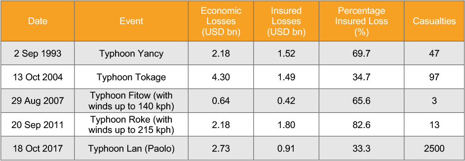
Table illustrating past typhoon events in Japan and their respective economic losses and percentage of insured losses. (Source: Swiss Re)
Outlook
Japan experiences multiple occurrences of natural disasters such as earthquakes, tsunamis and typhoons due to its location on the Pacific Ring of Fire and exposure to Western Pacific typhoons. Such perils are an annual occurrence in Japan and it has become a leader in risk management, with some of the most stringent building codes and effective emergency response.
JBA Risk Management has nationwide return period flood maps for Japan at 30m resolution. Please get in touch for more information.
References
Artemis, 2018, 'Japanese Insurers Losses from July Rains and Floods Rise into the Billions', viewed 4 September 2018
Artemis, 2018, 'Japan Flood Losses Estimated in the Billions: JLT Re', viewed 4 September 2018
Insurance Information Institute, 2017, ‘World Life and Nonlife Insurance in 2017’, viewed 5 September 2018
Kyodo News, 2018, '7 Dead, over 200 injured as typhoon hits western Japan, 5,000 stranded at airport', viewed 5 September 2018
Mallinson, H., 2018, 'Typhoon Jebi: Worst Tropical Cyclone in 25 years batters Japan', The Express, viewed 4 September 2018
Torii, S. and Mogami, K., 2018, 'Typhoon Jebi Causes Record Storm Surge of Over 3 Metres in Osaka', The Mainichi, viewed 5 September 2018